Chadburn Lake
Chadburn Lake Park is a public asset that provides access to world-class wilderness at our doorstep. It is the largest park in a Canadian municipality, over 18 times larger than Vancouver’s Stanley Park. The area was designated in 2010 as one of the five Whitehorse Regional Parks. The City adopted a Management Plan for the Park in 2017. The plan outlines 26 initiatives to be completed by 2028.
There are several formal and informal day use and boat launch areas located within Chadburn Lake Park. One of the most popular day use areas is Chadburn Lake itself.
The lake is a popular destination for canoes, kayaks, and paddleboards. Motorized boats are not allowed.
The site also features a small, pebbled beach and a floating dock. You can also find trails for hiking, biking, and cross-county skiing.
There is a large parking area, picnic gazebo, and a dock.
Three major gravel roads provide access within Chadburn Lake Park:
- Chadburn Lake Road
- Grey Mountain Road
- Long Lake Road
These roads branch off into smaller access roads that lead to lakes, trails, and other areas. Parking is available in designated locations throughout the park.
Access Chadburn Lake via the Chadburn Lake Road from the Riverdale neighbourhood.
Chadburn Lake Park contains an extensive network of trails, some of which connect directly to the Riverdale neighbourhood. Other main access points to the trails are located on Grey Mountain Road, Chadburn Lake Road, and Long Lake Road. The Chadburn Lake Park boundaries include most Whitehorse trails located east of the Yukon River. Sign posts are present throughout the trail network to assist with wayfinding. Trail maps can be found at parking lots at the Chadburn Lake Ski Trails, Grey Mountain Road, and Long Lake, providing overviews of each area respectively.
Maps
There are many popular activities that occur within Chadburn Lake Park. These include:
- Berry picking
- Bird watching and other wildlife viewing
- Canoeing
- Cross country skiing
- Fat biking
- Fishing
- Kayaking
- Mountain biking
- Orienteering
- Paragliding
- Rock climbing
- Running
- Sailing
- Snowshoeing
- Stand-up paddle boarding
- Swimming
- Trail walking/hiking
If you participate in an activity that is not listed above, let us know about it!
Chadburn Lake Park is home to a variety of wildlife. While the City does not have a direct role in wildlife management, it is responsible for administering land use policies and bylaws that can affect, and help to protect, wildlife habitat. Some wildlife information is available online:
- Angler’s Guide to Yukon Stocked Lakes (Government of Yukon)
- Caribou Herd Ranges (Government of Yukon)
- Stay safe in bear country (Government of Yukon)
- Wildlife in Whitehorse: A guide to our natural areas (Government of Yukon)
- Wildlife Key Areas (Yukon Government, Environment)
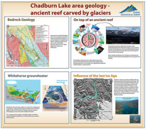
Chadburn Lake Park has a rich geological and cultural history. The City has commissioned a Historic Resources Overview Assessment for the area, which is currently in progress. The City is working with Kwanlin Dün First Nation and the Ta’an Kwäch’än Council to help inform the Chadburn Lake Park planning process.
Some heritage information is available online:
- From Trail to Tramway: The archaeology of Canyon City (Yukon Government, Culture & Tourism)
- Historic Sites Map, 2002 OCP
 Chadburn Lake Park is one of five Regional Parks located within the municipality of the City of Whitehorse. The city and its parks are located within the traditional territories of the Kwanlin Dün First Nation and the Ta’an Kwäch’än Council.
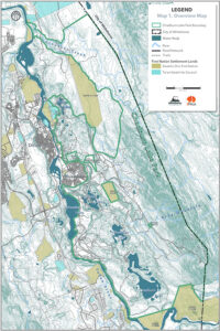
Chadburn Lake Park covers 7,550 hectares of City and Yukon Government owned lands, east of the Yukon River. The park boundary extends from Croucher Creek in the north to just past Chadburn Lake in the south, and from the eastern shores of the Yukon River and Schwatka Lake to the eastern municipal boundary.
The park encompasses four major lake areas:
- Chadburn Lake
- Chadden Lake
- Hidden Lakes
- Long Lake
Some notable features and amenities located within the park include:
- Biathlon Yukon lease area
- Canyon City and the historic Macaulay Tramway route
- Chadburn Lake Day Use Area
- Croucher Creek
- Fish stocked lakes (Hidden Lakes 1 and 3, Chadden Lake, and Long Lake)
- Grey Mountain
- Livingstone Trail
- Miles Canyon
- Rotary Cabins near Chadburn Lake
- Schwatka Lake Day Use Area
- Whitehorse Rifle and Pistol Club lease area
The following land parcels are excluded from the Chadburn Lake Park boundary:
- First Nations parcels
- A privately owned parcel located next to Grey Mountain Road
- Grey Mountain Cemetery
- City snow dump
As per the City’s Zoning Bylaw, there are three types of zoning that currently apply to Chadburn Lake Park:
- PE – Environmental Protection
- PG – Greenbelt
- PR – Parks and Recreation
The purpose of the PE and PG zones is to preserve areas in a natural state, with development limited to trails and interpretive facilities. Recreational uses such as beaches, boat launches, day use cabins, and outdoor participant recreation services are allowed as conditional uses in these zones, subject to a City Council approval process. The PR zone allows active recreational uses requiring facilities and/or infrastructure. This zone is limited to the Chadburn Lake Day Use Area, the Whitehorse Rifle and Pistol Club lease area, and part of the Biathlon Yukon lease area.
Development within the park requires the issuance of a development permit from the City, and typically requires a lease or license of occupation obtained from Yukon Government.

