
Vision Zero, Safe Mobility, and Traffic Management
Whitehorse is a community that values healthy and safe mobility for all, regardless of how we move.
Deaths and serious injuries in our transportation system are unacceptable, and the City and its partners
are committed to working together to eliminate them.
The City of Whitehorse is committed to safe mobility and making transportation safe and comfortable for people of all ages and abilities. The City’s Official Community Plan states that safety will be a priority when it comes to the design, construction, and maintenance of transportation infrastructure. In 2024, the City adopted a new Transportation Master Plan, which establishes a long-term vision for transportation in Whitehorse, and a target to eliminate fatalities and serious injuries from Whitehorse’s transportation network by 2040.
The City of Whitehorse is responsible for road safety and traffic management as it specifically relates to the City’s policies, programs, and infrastructure under its jurisdiction. Where the City has limited authority and jurisdiction, the City regularly collaborates with partnering organizations and government agencies (e.g. Government of Yukon, Yukon RCMP) to deliver initiatives and projects of mutual interest and influence.
The City of Whitehorse is responsible for the following:
- Design, operations and maintenance of the transportation network
- Development of City-specific transportation policies and bylaws
- Road safety, traffic management, temporary street use, and traffic operations
- Enforcement of parking violations
The Yukon RCMP is responsible for traffic enforcement within the City.
The Government of Yukon’s Department of Highways and Public Works is responsible for territorial transportation legislation and regulation, vehicle licensing, road safety education, and road user education. They are also responsible for the Alaska Highway corridor through Whitehorse.
The Safe Mobility Action Plan, to be published in the summer of 2026, seeks to prevent collisions leading to serious injuries and fatalities on Whitehorse roads, sidewalks, bicycle routes, and pathways. It focuses on making Whitehorse safer and more livable for everyone, with practical solutions that work today and prepare us for tomorrow.
The Plan will recognize that humans make mistakes and calls for a transportation system designed to be forgiving – minimizing the risk that those mistakes lead to serious injuries or death. This aligns with Vision Zero and the Safe System Approach.
Click here and see below for more information.
Safe Mobility Action Plan
The City is developing a Safe Mobility Action Plan, which builds on the City’s commitment to Vision Zero from the Transportation Master Plan and outlines a series of specific strategies and actions for the City to work towards eliminating fatalities and serious injuries from the transportation network.
Visit Engage Whitehorse to learn more about this initiative.
The report will be made available to the public in the summer of 2026.
Neighbourhood Traffic Calming
Traffic calming aims to use engineering and urban design to slow vehicles, reduce traffic volumes, and enhance safety for all road users. Implementing traffic calming measures can involve physical changes to street design (e.g. speed bumps) and regulatory changes (e.g. turn restrictions).
Every year, the City implements a series of traffic calming measures across Whitehorse to reduce vehicle speeds and create safer streets for everyone. While traffic calming is a great tool for reducing motor vehicle speeds and volumes, the City also uses education, enforcement, and other engineering projects to improve road safety. When assessing where traffic calming may be needed, the City will also consider if other solutions may be more appropriate for a particular neighbourhood.
The City implements seasonal and permanent traffic calming measures.
Visit Engage Whitehorse for more details.
Request Traffic Calming
The City has developed a Traffic Calming Framework that outlines a process for residents to request traffic calming. Requests for traffic calming can be made through a new tool and are evaluated on a yearly basis. Requests received by September 30 of each year will be considered for implementation the following construction season.
Click here to request traffic calming.
Pace Car Program and Kid Alert Sign Distribution
Whitehorse residents can show other drivers they’re taking a stand against speeding:
- Be the change on our roads and follow all the road rules and speed limits. Let’s drive right every trip and show them how it’s down.
- A lawn sign you can place in your front yard to remind drivers to slow down and drive safely. Click here to request a Kid Alert Sign for free.
School Zone Road Safety Campaign
The City is allocating $150,000 to school zone improvements every other year with the goal of raising awareness about road safety in school zones.
In 2022, the City developed an Active Travel Plan for École Selkirk Elementary School. It is the first plan of its type completed in Whitehorse. A school active travel plan is a program to encourage and promote walking, cycling, and rolling to school. The project consults with the school community and other stakeholders to help identify challenges and opportunities for school travel.
Speed limits for all streets in the City are shown in the Traffic Bylaw.
The City periodically reviews speed limits across the City to improve safety and ensure that speed limits match the surrounding context.
Neighbourhood Speed Reduction
In 2022, the City reduced speed limits on all streets downtown to 40 kilometres per hour. In 2025, the City reduced speed limits to 40 km/h on all streets in residential neighbourhoods throughout Whitehorse where the speed limit was previously 50 km/h. In addition, the speed limit on Hamilton Boulevard between the roundabout at McIntyre Drive and the south end of Falcon Drive was reduced to 50 km/h.
School Zones
The City implements school zones to reduce driver speeds and improve safety for vulnerable road users such as children at or near schools. Motorists should always watch for children and be aware of children near schools.
At schools that have school zone signage, the speed limit is 30 km/h. The playground zone starts at the “start of the school zone” sign and ends either at: the “end of school zone” sign, back of the school zone sign in the opposite direction or at the reinstatement of the prior speed limit.
Playground Zones
The City implements playground zones to reduce driver speeds and improve safety for vulnerable road users such as children at or near playgrounds. Motorists should always watch for children and be aware of children near playgrounds.
At playgrounds that have playground zone signage, the speed limit is 30 km/h. The playground zone starts at the “start of the playground zone” sign and ends either at the “end of playground zone” sign, back of the playground zone sign in the opposite direction or at the reinstatement of the prior speed limit.
Apply for a Street Occupancy Permit
The City manages street use and street occupancy for things like construction, partial or full street closures, parades, festivals, and protests. A street occupancy permit requires approval by the City Engineer.
Click here to learn more about Street Occupancy Permits.
Street Occupancy Permit Application
Construction
The City of Whitehorse has a short and intense construction season with much of our essential construction work happening during our summer construction months. The City and contractors strive to manage safety and traffic to protect all road users, construction workers, the general public, and minimize overall traffic disruptions.
Contractors wishing to use the street for construction purposes require a Street Occupancy Permit. A Street Occupancy Permit requires approval by the City Engineer.
Click here to learn more about our ongoing construction projects, upcoming road work and street closures.
Oversize/Overweight Vehicles
Carriers shipping oversize and overweight vehicles through the City of Whitehorse require a Street Occupancy Permit. A street occupancy permit requires approval by the City Engineer.
Parades, Festivals, and Protests
Parades, festivals, and/or protests on City streets require a Street Occupancy Permit. A street occupancy permit requires approval by the City Engineer.
The Yukon RCMP is responsible for traffic enforcement.
The City does not conduct enforcement of moving traffic (e.g., speeding, red light running).
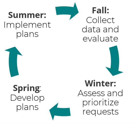
Evaluation and Monitoring
The City of Whitehorse regularly monitors and evaluates key performance indicators for the transportation network including but not limited to level of service (LOS), road safety, traffic volumes, and traffic speeds.
Traffic Data Collection
There are limited private traffic data collection services available in Whitehorse and throughout the Yukon. As such, select traffic data may be obtained through the City of Whitehorse or other third-party data providers. The City has equipment to collect screenline and turning movement counts using automated data collection devices.
The City can provide data collection services (labour, materials, set up) and provide raw, unadjusted data at cost upon request. In exchange for provision of new traffic data, the City obtains the data as per its requirements and retains ultimate ownership of the data.
Click here to request traffic data.
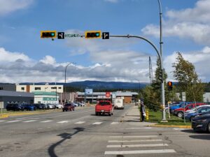
Traffic signals are a traffic control device used to manage the safe movement of road users including pedestrians, cyclists, transit users, and vehicles. Traffic signals may be installed for safety, operational, physical, strategic, and special considerations.
The City of Whitehorse installs, operates, and maintains traffic signals within the City, except those on the Alaska Highway through Whitehorse.
The Government of Yukon’s Department of Highways and Public Works installs, operates, and maintains traffic signals along the Alaska Highway through Whitehorse.
Upcoming Traffic Signal Changes
| Location | Date | Description of Changes |
|---|---|---|
| Select locations | August 2026 | Lead-Pedestrian Interval & Rest-on-Walk |
Eligibility and Criteria for Installation
The City periodically reviews intersections to identify the need for traffic signalization and improvements. Traffic signals may be warranted when any of the following conditions are met:
- History of collisions between road users.
- High pedestrian volumes across an intersection with insufficient gaps for safe pedestrian crossing movements.
- High through or left turn volumes from a minor approach at a major-minor intersection with insufficient gaps for safe vehicular movement.
Traffic Signal Operations
Traffic signals are programmed to facilitate the safe and efficient flow of traffic and minimize conflicts between all road users. The City periodically reviews traffic signal timing and programming for all signals to ensure that the traffic signals meet the ever-changing and dynamic needs of traffic.
Our traffic signals operate by assigning the right-of-way to different traffic movements. Each phase includes the green, amber and red time assigned to a specific traffic movement. The cycle length is the total time it takes to serve each phase. Increasing the cycle length improves the intersection capacity by providing longer continuous green time, but also increases the average delay for vehicles waiting at the intersection.
Types of Traffic Signal Operations
The City uses three types of signal operations:
- Fixed time: there are no pedestrian or vehicle detectors. The time given to each phase is preset and independent of vehicle volumes and demand.
- Semi-actuated: there are pedestrian and vehicle detectors along the minor street only. When there is low demand, the minor street phases are able to end early or be skipped entirely when no vehicles are present. Excess time is transferred to the major street phase. Pedestrians crossing the minor street will be served each cycle, while crossings of the major street will only be served by using the pedestrian pushbuttons.
- Fully-actuated: there are pedestrian and vehicle detectors for all directions of travel. Phases are served, extended, or end early depending on traffic demand. Pedestrians will only be served when the pushbuttons are used.
Traffic signal timing and programming is prepared by modelling existing and projected traffic demands and optimizing traffic flow using industry traffic modelling software. Traffic signal modelling and timing is usually conducted by a civil engineer with specialized expertise in traffic operations.
Timing Plans
Different timing plans are often used throughout the day to reflect changing traffic conditions. At most intersections, morning and afternoon plans accommodate both rush hour periods, while a non-peak plan for the remainder of the day. Traffic signals in Whitehorse are typically programmed for the following times:
- Weekday
- Morning traffic peak hour (07:00-09:00, Monday-Friday)
- Mid-day traffic peak hour (11:00-13:00, Monday-Friday)
- Afternoon traffic peak hour (15:00-18:00, Monday-Friday)
- Weekend
- Mid-day traffic peak hour (11:00-13:00, Saturday)
- All other times
Pedestrian Phasing
The pedestrian walk interval indicates that pedestrians at an intersection may cross the street. The pedestrian walk interval is usually indicated by a white human symbol on a pedestrian signal head.
The pedestrian clearance interval indicates that pedestrians at an intersection may not cross the street as the traffic signal will change to the opposing direction. The pedestrian clearance interval is usually indicated by a red flashing hand symbol on the pedestrian signal head. The pedestrian clearance interval is timed to allow pedestrians of all ages and abilities to safely finish crossing the intersection before the onset of conflicting traffic flow.
Vehicular phasing
The green interval indicates that a vehicle may proceed in the direction of travel flow. The amount of green time allocated to a particular phase depends on a variety of factors such as location, time of day, traffic signal operation, current traffic demand, and traffic analysis and modelling.
Emergency Vehicle Priority and Pre-Emption
Traffic signals in the City are equipped with acoustic pre-emption devices. Acoustic pre-emption devices are devices fixed on traffic signal arms to aid emergency response vehicles in responding to a call. When the device hears the sound of an emergency siren, the device will send a call to the traffic signal in the direction of an oncoming emergency vehicle.
Left Turn Phasing
Accommodating left turns in the transportation network can be difficult as it has the highest conflict potential. Installation of left turn phasing may be required in special cases to facilitate safe and efficient left turn traffic, however, often increases the overall cycle length and delay for all road users at an intersection.
No Right Turn on Red
Some signalized intersections in the City have no right turn on red to minimize conflicts between right turning vehicles and pedestrians and cyclists.
Turn Restrictions
Turn restrictions may be implemented at locations to improve the safety and efficiency of traffic.
Flashing Signals
Occasionally, traffic signals malfunction and/or experience power outages.
- If the traffic light is flashing red, treat it like a stop sign.
- If the traffic light is flashing yellow, treat it like a yield sign.
Power Outage
At older traffic signals in the City, lights may not be illuminated in a power outage. If no lights are illuminated, drivers should treat the intersection like a four-way stop.
Detection
Pedestrian and Bicycle Detection
At intersections requiring pedestrian detection, pedestrians are detected by pushbuttons installed on the traffic signal.
At intersections requiring bicycle detection, bicycles are detected by bicycle-friendly pushbuttons installed on a separate pole away from the main traffic signal pole.
Vehicle Detection
At intersections requiring vehicular detection, vehicles are typically detected by electromagnetic induction loops. Electromagnetic induction loops are located within in the pavement surface behind the stop bar on an intersection approach. When an electromagnetic induction loop detects a high concentration of metal, the loop sends a call to the traffic signal.
Smaller vehicles may not always be detected by a traffic signal due to the low volume and concentration of steel. This may include motorcycles, bicycles, e-bikes, etc.
Become a Traffic Operations Engineer
Have you ever wanted to try being a traffic engineer? Have you ever wanted to try solving traffic problems?
Click here to play the Gridlock Buster Traffic Control Game to learn about traffic signal timing and programming.
Learn More
Here are some resources on traffic signals:
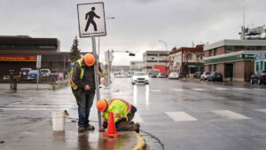
The City of Whitehorse installs and maintains signage and pavement markings on City streets to inform road users about rules of the road, regulations, potential hazards, temporary conditions, construction, and guidance and wayfinding.
Standards
The City of Whitehorse installs and maintains signage, pavement markings and other traffic control devices as per the TAC Manual of Uniform Traffic Control Devices for Canada (Transportation Association of Canada) standards, TAC guidance, and City of Whitehorse Engineering Standards.
All signage and pavement markings installed on City streets require approval by the City Engineer and the City Manager.
Pavement Markings Program
The Fleet and Transportation Maintenance Department reinstates pavement markings each year. Typically, longitudinal pavement markings are implemented earlier in the summer season (May) and transverse and other pavement markings (crosswalks) are implemented afterwards and throughout the summer season.
Painted Curbs and Medians
The City does not paint curbs and medians to indicate traffic regulations (e.g. parking regulations) except in the following locations/circumstances:
- The nose of medians to aid drivers and maintenance operators in identifying raised directional divisions in traffic.
- Crosswalks & crossrides with reported safety concerns validated by an engineering study.
- Locations where installing signage is practically unfeasible or would cause adverse impacts to other road users (e.g. clear width available for people with mobility devices).
- Locations where the traffic bylaw and signage cannot adequately communicate traffic regulations.
Crosswalks
Marked crosswalks are a traffic control device used to alert drivers to areas with high pedestrian crossing activity and facilitate safer passage of pedestrians crossing the street. Not every location with pedestrian crossing activity is a candidate location for a marked crosswalk as many factors need to be considered, including, but not limited to, driver expectancy, proximity of marked crosswalks, and local context.
There are three types of marked crosswalk systems:
- Passive crossing treatment system: consists only of signs and pavement markings
- Active crossing treatment system: consists of signs, pavement markings, and pedestrian-activated warning devices, such as flashing beacons
- Traffic signal system: consists of signage, pavement markings, and pedestrian-activated traffic signals
Marked crosswalks are typically installed in locations with:
- Insufficient gaps in traffic for safe pedestrian crossing
- High pedestrian crossing volumes
- High concentration of vulnerable road users (e.g. children, seniors, people with disabilities) and/or historically marginalized people (e.g. low income persons)
Crossrides
![]()
(City of North Vancouver, 2023)
A crossride (also called elephant’s feet markings) are dots that are parallel to crosswalk markings that tell cyclists they do not need to dismount when crossing an intersection. Crossrides are mostly found at areas where bicycles use City streets such as multi-use pathway and bicycle lane intersection crossings.
Pedestrians should watch for crossrides so they do not accidentally walk in a crossride area. Cyclists should always yield to pedestrians, slow down and only cross when it’s safe. Motorists should watch for crossrides, slow down and yield to anyone using the crossing.
Marked crossrides are typically installed in locations with:
- High cycling crossing volumes.
- Multi-use pathways intersection crossings.
- Bike lane intersection crossings.
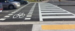
Separated crossride (left) and crosswalk (right) at a signalized intersection (City of Sudbury, 2023)