-
-
-
-
-
You May Be Looking For
-
-


City News Highlights
July 18, 2025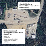
Changes coming to Household Hazardous Waste disposal
July 18, 2025
The City has launched its first online interactive trail map to share information about City-maintained trails within the municipal boundaries of Whitehorse.
The map includes details for each trail, displaying primary and restricted uses along with difficulty level, surface type and width.
The City Trail Network features both paved and natural surface trails. This new map identifies various recreational opportunities throughout the network and allows trail-goers to plan their route and their preferred way of moving through our wilderness city.
Be sure to check for any trail advisories, closures or detours identified on the map!
The map is available at whitehorse.ca/trails and is viewable on home computers, laptops, tablets and mobile devices.
Trail users are encouraged to try the new map and provide feedback to [email protected].