
Schwatka Lake
The area is a popular destination for boating, fishing, canoeing, sightseeing, picnicking, hiking, biking, and swimming.
The day-use area features a boat launch for motor boats, and a dock for swimmers. There are many unmarked picnic areas close to the lake.
The 15 km Yukon River Loop trail passes through the area, and is a great way to tour the lake and visit Miles Canyon and Canyon City.
Visit our Chadburn Lake Park page to learn more about the area.
Directions
The day-use area is located along the eastern shore of Schwatka Lake and can be accessed by Chadburn Lake Road in the Riverdale neighbourhood.
The White Horse rapids on the Yukon River once flowed where Schwatka Lake stands today. In 1958 the river was dammed to generate hydro-electric power and the lake was created. A watershed area of approximately 3,500 square km drains directly into the lake. Riparian, wetland, and forested areas provide habitat for loons, grebes, ducks, and other wildlife. The area is a popular destination for bird watchers.
The Schwatka Lake area has historically been used by Indigenous Peoples and is located within the traditional territories of the Kwanlin Dün First Nation and Ta’an Kwäch’än Council.
The area is also historically significant for its role as a water and rail passage during the days of the Klondike Gold Rush. Traces of the Hepburn Tramway (constructed in 1898) can still be observed, while tracks of the White Pass and Yukon Route railway (completed in 1900) remain intact, albeit overgrown. The rail operated until 1982, when it was suspended due to a downturn in the territory’s mining industry.
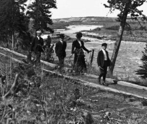
People walking along the Hepburn Tramway (photo credit: MacBride Museum of Yukon History collection, 1989-3-1-344).